
Maps and photos note: click or tap to see any maps or photographs below as a high resolution version.

This walk explores the riversides upstream of the Dogleap Centre. This is a landscape moulded by the human requirements for water power, linen production and the milling of gain for bread, feed and even whiskey. There is a Linen Green, the remains of three weirs and mill race systems and many ruined mills and associated buildings. At the turn of the walk you have an option to leave the Country Park and visit a tranquil church following the “old ways” along a rough unmade path.
Details of walks and options below. Note that you do not need to decide which option to take until you reach the bridge at Carrick Mills. If you do proceed to the second bridge at Carrick Church you still may wish to retrace this section rather than leaving the Country Park after the bridge and walking on un-maintained paths.
Long Option
| TYPE | Linear riverside walk (with option to cut short) |
|---|---|
| DISTANCE | 3.7 miles / 6 km |
| SURFACES | Mostly well made asphalt and compacted surfaces with gentle slopes. South section to Carrick Church much steeper with rough steps, bare rock and potentially muddy sections |
| HEIGHT GAIN / LOSS | 330 feet climb |
| HAZARDS |
|
Short Option
| TYPE | Linear riverside walk |
|---|---|
| DISTANCE | 2.4 miles / 3.8 km |
| SURFACES | Well made asphalt and compacted surfaces with gentle slopes. Very few steps. |
| HEIGHT GAIN / LOSS | 140 feet climb |
| HAZARDS |
|
The Route
Leave the main visitor centre car park by the traditional white pillared gate and turn left along the vehicle track heading towards the river passing the old beetling mill on your left. Now turn right by the small field (there may be goats to admire here) and continue until the track joins the river bank.

This will be a walk dominated by the river and the historic industrial landscape of water power. Along the large field to your right you should be able to make out the line of the restored primary mill race sitting on the high lip of the flood plain edge. Shiny new sluice gates are visible here too and presumably one day soon they will open and release a controlled torrent again down to the power house and hydroelectric generated electricity will flow into the grid for first time since 1962.
Straight ahead a loose collection of red brick buildings mark the location of an old ‘wash mill’ where brown linen was processed on its way to becoming white. This was done by a combination of chemical and mechanical processes and natural beaching by sunlight (when available) . A smaller mill race used to flow here between the river and the high level race – you will see its upper reaches shortly.

Just past these building you come to a very level triangular field on your right – this was the bleach green which gave the Largy Green and the associated ‘Green Bridge’ its name. Here linen cloth was stretched out after being treated in the wash mill to bleach in the sunshine. As you can imagine this was a slow and laborious process, but one which in later years was greatly accelerated by advances in industrial chemistry (although not to the benefit of the river environment). As the cloth was valuable and vulnerable it had to be guarded day and night and you will pass one of the original watch towers – still intact with its stone roof.

A the end of the bleach green you enter a narrow strip of riverside forest where you will find the truncated mill race which once fed the mills on the bleach green you have just passed. You follow this now quiet waterway for 600m until you reach the weir and sluice gate which once funnelled water from the River Roe into the milling system. Today it is a tranquil spot and a favourite spot for fishing herons.

Continue past the weir and sluice until you come to the wooden footbridge at Carrick Mills. This was formerly a ford and the two lanes either side still terminate at the water’s edge, Old maps show stepping stones here too but the modern bridge is a better option if you wish to follow the shorter, easier version of this route. Just skip ahead to downstream from Carrick Mills.

Upstream to Carrick foot bridge
The longer option continues straight ahead along the river with shallow rapids visible between the trees. Here you stand a good chance of seeing a dipper feeding and and almost flying in the water itself. This small dark bird might be mistaken at first glance for a starling having a paddle – but its white bib and remarkable continuous bobbing action give it away. Once you see it fly into, and under, the bubbling water to feed on insects you can’t mistake it, or forget it. I do have a picture of a dipper taken on this section – but there is no point in including it here as these birds are all about movement – not stillness!
As you proceed upstream the big mill race converges in from your right. You also begin to see evidence of the recent re-engineering work and you arrive at a galvanised bridge over a spillover weir (which can return excess water to the river). Here the through path turns sharp right, but I suggest you continue straight ahead onto the richly oak wooded ‘island’ between the race and river. The verdant natural woodland here contrasts with the harsh grey metalwork of the newly installed water channel infrastructure. Sadly we seem to have lost the Victorian flair for celebrating and enjoying our engineering landscape interventions. I do believe that generating power again from the Roe is exactly the right thing to do – but I hope it will be done without reverting to unnecessary ugliness.

Retrace your steps to the metal bridge and turn left upstream. The path now begins to climb at a more energetic rate and bends away from the river. After 300m and a short steep section you find yourself walking along the edge of farmland and approaching the south most of the Country Park car parks.

At the car park take the path sharply downwards back to the river. There are steep steps here but with a handrail, and the elegant metal “double inverted bowstring” bridge ahead has recently been fully restored by the Park authorities.

On crossing the bridge you find yourself at the edge of the Country Park and while there is a substantial flight of concrete steps ahead up to the church – a sign here warns that the path ahead is in poor condition and not a formal part of the park access network. It is now up to you to make your own decision. Retracing your route to the Carrick Mills footbridge is a perfectly pleasant option (and the view is different the other way around). If you decide to go ahead then you must take responsibility to assess the path for yourself as you go.
The section up to the church on solid concrete steps with a handrail should normally be straightforward.

Skirt around the exterior of the church. It is unlikely to be open, but the building lends a calmness to the forest clearing it sits in. A good place to stop and reflect whatever your source of value.
Head away from the church front front along the boundary wall to an unmistakable stone stile and climb over back into the wood.

The bare earth path now drops steeply through the woods, there are exposed roots, rocks and overhanging trees. Of course, the very things which make this path less ‘accessible’ are also the same things which make it authentic and a feast for the senses. There is also the feeling as you drop below the cliff that you are following a route used by local people for hundreds, if not thousands of years before.

All too soon you will come out of the dense natural woodland and onto a ‘beach’ by the uppermost of the Country Park weirs. This weir and the now heavily overgrown sluice and mill race beside it, once fed the flax and corn mills just downstream by the wooden footbridge you passed earlier. This is an area which might flood after heavy rain so proceed with caution.

A sign informs you that you have re-entered the Country Park and your way ahead is now once again approved. Head downstream and you will shortly arrive opposite the new sluice gates you saw earlier. Continue downstream as the path skirts farmland on your right and a number of disused mill related buildings (and a fine brick chimney) come into view.

Now pass the wooden Carrick Mills bridge and continue downstream to the last cluster of mill buildings adjacent to the Carrick Rocks car park. As you squeeze between the last mills and the river you are actually walking in the cutting of a former water wheel and its two bearing are still clearly visible. The next section downstream is easy and pleasant with farmland on your right with livestock present to add interest. In spring the hawthorn and blackthorn bloom here is spectacular. After a time the path re-enters the woods and undulates gently along the base of a steep section before emerging in enclosed meadows.

A final short wooded section running close to the river brings you out at a broad bend where the bank has been modified to accommodate wheelchair using fishermen. Looking up at the steep slope you can still see some bare reddish earth, lingering evidence of the massive earth slip which closed this section of the path some years ago. The black basalt retaining wall at your right is part of the re-instatement works. For all its apparent solidity this is not a static landscape – everything around you is moving, in its own time!
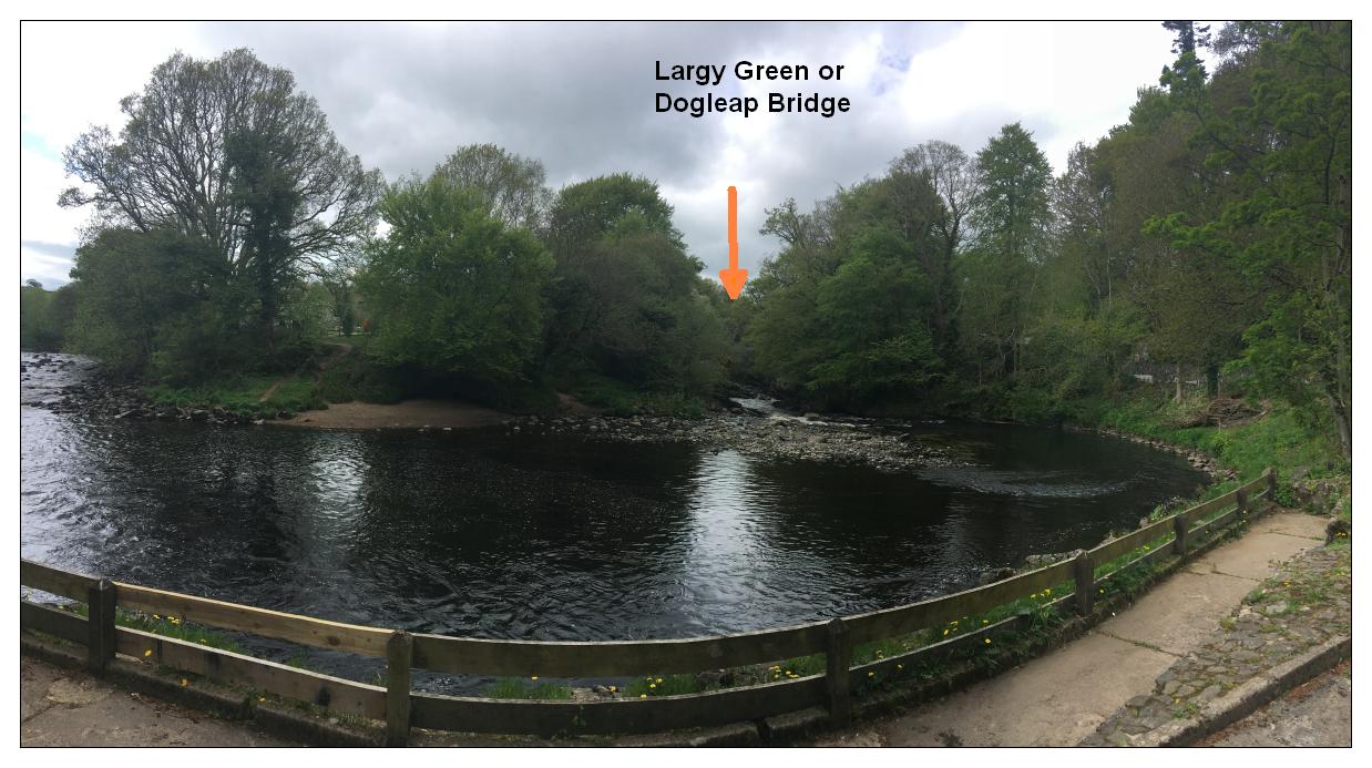
Looking downstream, depending on the season, you may be able to see the Largy Green Bridge (from the townland of Largy and the linen green) or Dogleap Bridge (from the legend of the O’Cahan’s hound who escaped from the besieged castle, leapt across the gorge here and ran to Dungiven for help – beating Lassie to this plot device by several hundred years)!

The bridge, rocks and rapids here feature in a multitude of watercolour and oil paintings which hang on many Limavady walls (and those of a few exiles too I dare say). It is a great scene but not easy to paint (or photograph) – much of its appeal comes from the movement and sounds of water, its ever changing cloaking and the turn of the seasons. Therefore I suggest the best way to enjoy it is to visit regularly and enjoy the real thing!
The path now leaves the riverside and joins the minor public road at a small car park. Turn left here and proceed along the road to the bridge with caution. There is no footpath but the traffic is necessarily slow because of the tight turn and the single track bridge.

Just before you cross the bridge there is an echo of past suffering – the broughan house. The name derives from brachán the Irish for porridge and this where food relief in the form of porridge was given out during the great potato famine. Ulster suffered less than the rest of Ireland because of the Linen industry – farmers here alternated their potato crops with flax so when the blight struck they still had the income from the sale of flax. That the broughan house was situated here might indicate that some of the wealth of the linen industry was returned to the people whose hard labour made it possible.
Carefully cross the bridge, but don’t forget to look down at the cascades and water sculpted rockscape below.

You are now back at the Dogleap visitor centre where hopefully the cafe is open and you will be able to reflect and recharge.