Descriptions with maps, travel details, distances, physical difficulty of walks and other ways to explorer the great outdoors and have yourself a “Grand Day Out”
Earth /gravel / grass paths, generally in good condition
HEIGHT GAIN / LOSS
308 feet climb
Hazards
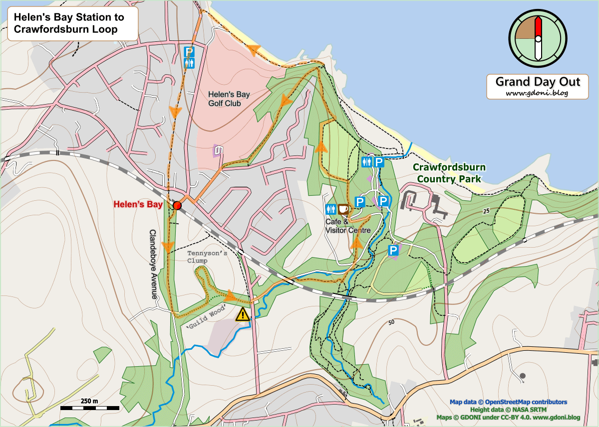
Optional woodland small path steep and muddy in places
This route starts from the Country Park visitor centre; however, should the centre and lower car park be closed, the car park on the access road should provide a suitable alternative.
Dangerous concealed drops to river near waterfall (stay on path)
This route starts from the Country Park visitor centre; however, should the centre and lower car park be closed, the car park on the access road should provide a suitable alternative.
2.2 miles / 3.6 km (Chimera Wood option) 2.6 miles / 4.2 km (Clandeboye Avenue option)
SURFACES
Mixed tarmac and earth/gravel – generally good.
HEIGHT GAIN / LOSS
250 feet of descent and ascent
HAZARD
– a busy road crossing – short walk along the park access road without pavement (but with pedestrian marked lane)
This is a circular walk which does not require a train to complete. However, starting from Helen’s Bay station provides both easy access and a start with a surprise! There is a car park here but it is often full during commuting hours.
Work is currently (December 2021) ongoing to alleviate flood risk from the Shimna river from Tipperary Woods to the seafront. There is currently no public access through Tipperary Wood or Island’s Park onto Byransford Road.
In the meantime the yellow route marked above along the Tullybrannigan Road will bypass the works and allow you to join the original route at the junction of Tipperary Lane and Tullybrannigan Road. Plaese note that this will require a short section (300m) of extra walking along a country road without a pavement.
This route starts in Newcastle, follows the Mourne way to Tollymore and on to the high points of Curraghard (738 ft) in Tollymore and Drinahilly (833 ft) in Donard Wood. Both sites offer fine views over Newcastle and Drumdrum and into the higher Mournes behind. The heights are significant, bearing in mind that the Mountains of Mourne do drop down straight to the sea, but the surrounding forest provides protection from the worst of the wind. Underfoot conditions are generally good but with short steep, rough and muddy sections.