
Maps and photos note: click or tap to see any maps or photographs below as a high resolution version.

| TYPE | Coastal loop walk mainly on tracks but with short rough shore section (easy linear option). Significant climb required. |
|---|---|
| DISTANCE | 3.5 miles / 5.6 km |
| SURFACES | Mostly well made compacted surfaces with variable slopes except for short rough coastal section (no path) |
| HEIGHT GAIN / LOSS | 900 feet climb (linear option extra 100 feet) |
| HAZARDS |
|
Murlough Bay is one of our wildest and most beautiful places. If we had National Parks, this area should be part of one. However, it is not pristine wilderness – its rocks, woods and plains tell a story of long human occupation, farming, mining and spirituality – all adding richness to the fascination of this unique place.
Getting there
Murlough Bay is clearly signposted from the main A2 Cushendall Road. Look for the brown tourist sign 2 miles from Ballycastle on a sharp bend. There follow several more turns on minor roads, but all are well signposted. The final section of the approach road is single track, but straight with easy gradients and good visibility of any oncoming traffic. However there no passing places and you may have to use the road verge (with care)!

About 400m after passing a lime kiln on your left you come to a small rough car park. It has a upper and lower exit, but a pile of stones blocks access between the two (Nov 2025).
There are no maps or interpretation panels to inform the accidental tourist – but this is definitely the best place to halt, park and get walking. (There is nothing to stop you driving all the way down to the bay along a steep, unguarded, winding single-track road with almost no passing places – but why would you swap a great walk for a white knuckle drive!)
The view over Murlough and then to the sea and Scotland beyond is spectacular. I have marked a viewpoint here, but in reality it is almost impossible to find a place in Murlough Bay which doesn’t have a superb view!

The area below is grazed by sheep and cattle. Therefore, as always in these circumstances, I would not recommend bringing a dog. Even on a lead they can distress and cause damage to livestock.
The law here is very clear (although often ignored by selfish dog owners).
It is a criminal offence under the Dogs (Northern Ireland) Order 1993 to allow a dog on any land containing livestock unless the dog is under control. The Order defines ‘under control’ as ‘restrained by a chain or other sufficient leash held by a person exercising proper control over the dog’.
Sheep and Livestock worrying Quick Guide (Dept. of Agriculture, Environment and Rural Affairs)
As a result of people frequently ignoring this law, farmers are increasingly, and completely understandably, insisting on a “No Dogs” rule for land they permit access to. Please never ignore such instructions.
The Route

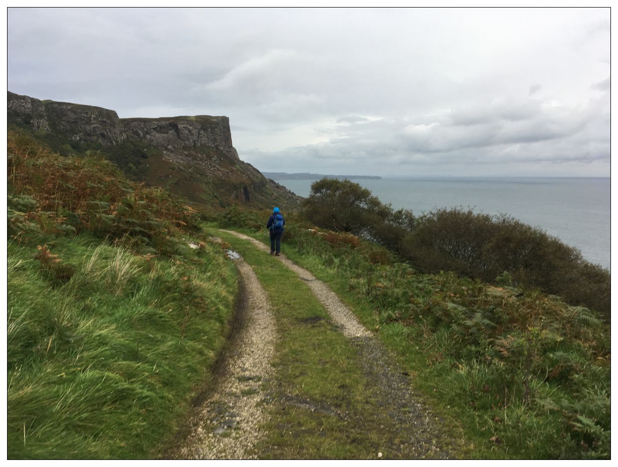
There are many aspects to the beauties of Murlough Bay – sea – rock – wood – sky- history. However, as you leave the car park looking ahead over the restless, tide surging Moyle far below and away – there is a sense of power and place unlike anything I have experienced elsewhere in my many years of coastal walking. It is impossible to photograph – it can only be experienced!

Head down the hill on the tarmac road soaking in the view for 900m to a hair-pin bend and small parking area. Now turn left off the tarmac down hill towards the towering Dolerite cliffs of Fair Head.

This is a complex layered world which exposes part of the spectrum of geological time. You started on limestone composed of the bodies of creatures from an ancient sea. In front of you are the Dolerite cliffs formed by a lava flow injected between existing rock layers. Under this is more organic remains including coal from an ancient forest, chalk and flint rich red clay.
After 100m the track splits – the minor track to the left leads straight into the natural Birch, Rowan and Hazel woodland. However, this is hiding the massive scars of previous coal mining. Adits and shafts were dug into the rock here and modern aerial photography clearly shows a complex network of straight lines. The Ordnance Survey map of 1850 shows these same lines as the tracks and mine workings of Murlough Colliery. I recommend a short diversion on the left hand fork to get a closer look.

If you have diverted – return to the track and fork right downhill dropping into the woodland. On our walk we disturbed deer here, showing it’s not only plants and trees which thrive in this rich ecosystem. If you are walking on a blustery day with prevailing westerly or south-westerly winds, you will be struck by how calm it is here in the cradling of the cliffs above. This situation creates a micro-climate, which in turn explains much of the natural richness around you.

Shortly below this junction you come to two places where landslips have eaten into the rough track. Negotiate these on the uphill side with care.

Continue downhill – the East Point of Rathlin Island, with its lighthouse, should be visible ahead.

Shortly you will pass the overgrown track cutting back to the shore cottages. However, it is easy to miss from this direction, so it is sensible to first walk to the end of the track to a flat level area on the edge of the cliff foot Boulder Field. I have marked this massive area of giant chaotic fallen rocks on the walk map as a ‘Boulder Jungle’ as ‘Field’ makes it sound managed and benign – which it is anything but. Over the years many unwary individuals and groups have had to be rescued from these energy-sapping, relentless miles of rocks and overgrown holes,

Now turn around and retrace your steps for just 100m. As the level track begins to climb again and just before an old wall end, an initially old track cuts off to the left, directly towards a row of ruined cottages on the near skyline.

The track here is overgrown with some wet patches, but it follows a solid rocky base and those with proper outdoor footwear should be able to follow it easily for the next 150m to the cottages.

The ruins are not stabilised so treat with caution and stay out. However, the outside of the north gable is well worth a look. It has deeply pitted blocks of sandstone and in places large holes have been carved out through the full depth of the wall! On the seaward side of the cottage the remains of a bench mark a great spot to stop and look out over the Straits of Moyle.

The tidal range here is less than 1m (compare this to 4m at Belfast), but what the Straits of Moyle lack in rise and fall they more than make up for in speed and strength of current. A travelogue from 1903 claims this place is the original Corrievreckan whirlpool – a name now attached to a straights between Jura and Scarba 70 miles to the north.
The Irish call it Sloch-na-marra, ” the swallow of the sea,” which is descriptive enough; and it has another name, Coire-Brecain, ” Brecain’s Cauldron,”since the day when Brecain, grandson of Niall of the Nine Hostages, was engulfed there with his fleet of fifty curraghs.
Highways and Byways in Donegal and Antrim, Stephen Gwynn
Jumping forward back to the time of the colliery there was a wooden pier projecting just to your left from the rocks below, It must have been a hazardous business shipping coal from under these great cliffs.
If your mobility or flexibility is limited, the cottages are a good point to turn back and retrace your steps to the point where you left the surfaced Murlough Road above. The coastal route ahead contains a 350m section with no track and it is necessary to ‘clamber’ along a rough shoreline where a slip could result in a twist or sprain (remember there is little or no mobile signal here).
Otherwise return to the overgrown track and continue gently downhill for the next 250m.

You will pass another ruin below, almost on the rock shore. The wallsteads tell of a substantial multi-storey building – some form of barn or warehouse. Interestingly the OS first series (1832 – 1846) shows ruins here, and at the location of the cottages. The second series (1846 – 1862) shows buildings in both locations – so both sites may well have had a previous life and function.
Your path fades to nothing as you reach the rocky shore at Portdoo. You now have 350m of slow progress, picking your way above the shore-line. In September 2019 there was a clear, well used sheep track here – but what is easy for four-legged sheep is not so good for two-legged walkers! Be warned.

Ahead the rocky Drumnakill headland comes back into view – its base is your target where firm footing awaits on another old miners track.

As you approach Drumnakill headland the line of a clear and level track, cut and built through the cliff foot boulder field becomes clear. This is a substantial piece of engineering, reminiscent of the mysterious ‘Old Coach Road’ of Orlock Head. That causeway was built by Welsh miners, but this one seems to pre-date the Colliery workings and may instead relate to older inhabitants of this land. Drumnakill is the site of an ancient Christian Church (we will see ruins later). However, irrespective of era the original purpose of this dead-end-track is not clear.

Straight and level – this track is a railway grade ‘permanent way’ before its time!

As we followed the track around the headland we met another large group of walkers coming the other way – sheep! Just visible in the photo above.
You now enter the relatively dry and fertile pasture of Drumnakill where sheep safely graze in significant numbers. Tree lined hedges and dry stone walls frame an idyllic landscape which seems a world apart from the barren rocky shoreline you traversed to get here. As always, hidden geology will play its part, but so too will have many generations of farmers’ care. Seaweed, which is rich in multiple chemicals, would have been fetched and spread here, but as you will see shortly, an alternative soil improver was also available.

As your path crosses the pasture and joins the tarmac road, continue straight ahead where you will shortly pass a lime kiln. Presumably this would have burnt locally mined coal as it turned chalk into quicklime which could be used to improve the natural acid soils of the surrounding fields. The quicklime was also needed for white-wash and mortar so the owners of Murlough Bay would have once had control of a key economic resource.

The OS first series (1832-46) shows a significant house at the end of a winding drive in the woods just above the track and the current day townland name of ‘Bighouse’ is suggestive.

You now pass through gate by a small cottage (now a bothy) with rock stacks to your right. Around the next bend you come to the Murlough Cottage at the end of the road. This is a private dwelling so please respect this.

There is a small dirt path which passes the house on the seaward side and continues beyond, but for this route it is your point to turn back. On the plus side the views are now even better as you are now walking directly towards Fair Head.

Look out for the interesting square banked form on the headland. Maybe an old sheep pen or perhaps something older and more interesting.
The tarmac road here is suffering ongoing subsidence – this is a landscape on the move!

Follow the tarmac road back past the junction with the Drumnakill headland path. After a further 150m leave the tarmac road and strike out along the sheep pasture to gain easy access to higher ground (avoid the line of low crags). Now head seaward above the rocky slope until on rounding some rocks you come to the remains of an ancient church, just below an isolated tree.

I have visited the sites of many early Christian Irish churches, but can’t think of a more dramatic one than this. Here the characteristic tiny rectangular footprint and thick walls seem to have been augmented by at least cosmetic care. The whitewashed (appropriately) altar suggests more modern use.
This church would have once been at the heart of a community here, with fishing, farming and almost certainly sea-borne trade and exchange. Look around and imagine it if you can.

Return to the tarmac road and begin your ascent along the tree lined route. As you climb, look back for an overview of the the headland. Geologically this is all a land slippage and you may have seen clues that even today land movement continues with displaced roadside reflectors and indeed a warning road sign!

As the track levels you come to a hairpin bend, rejoining your earlier route. Stay with the tar and continue your climb, always bearing in mind the possibility of meeting a descending car on this narrow way.

Just under a kilometre will bring you back to the car park on the lip of the bay.
Walk description updated November 2025
Route Map to Download and Print (PDF)
External Links
- Lime Kilns (Oughterard Heritage Site) – short article on Kilns in Ireland
- Burning the Bones of the Earth: Lime Kilns (Low-tech Magazine) – detailed item with comments
- Survey of Lime Kiln at Murlough Bay County Antrim (Ulster Archaeological Society)