
Maps and photos note: click or tap to see any maps or photographs below as a high resolution version.
| TYPE | Circular walk from train station |
|---|---|
| DISTANCE | 1.6 miles / 2.5km |
| SURFACES | Mixed – significant muddy and rough sections |
| HEIGHT GAIN / LOSS | Several gentle ascents and descents – 200 feet of height gain and loss. |
| HAZARDS |
|
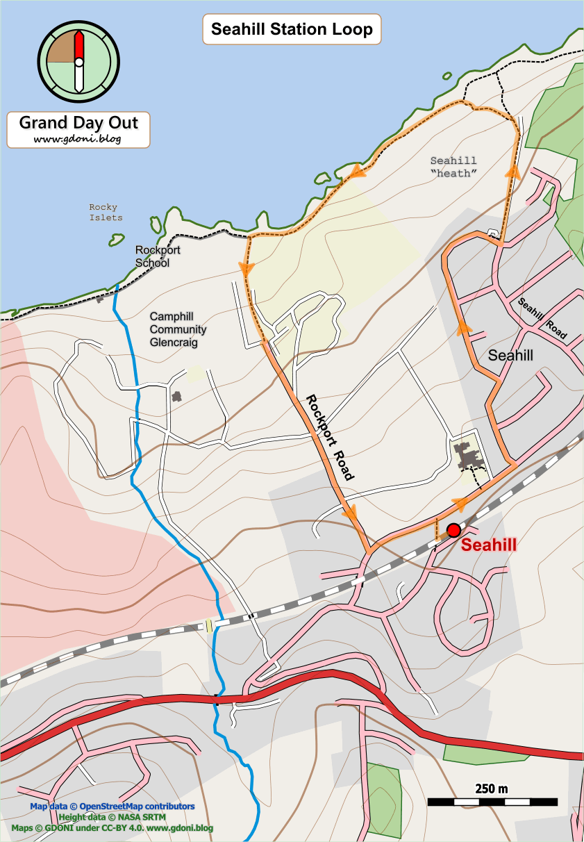
This is an excellent short walk which gives quick access to the seafront north of Seahill with its diverse shore habit, rocky coves and small rocky islets close to the shore where cormorants and seals can often be seen. A great spot to sit and watch (or even picnic weather permitting)!
This circular walk essentially features extracts from the Helen’s Bay to Seahill and the Seahill to Cultra walks. The text is lifted from these routes so you may find it familiar!
Exit the station onto Seahill Road and turn right. After 100m turn left into Craigdarragh Park Road. You are now in the heart of Seahill, a large development of 1970s bungalows and split level living. There is much to like about this style of built environment – the plots are generous – usually with real gardens front and back (palms flourish and hints of rockeries abound). Property boundaries are low and inclusive – almost American in style. The houses feature the large windows and varied geometry of a modern forward looking architecture. Yes, the buildings of this period often used indifferent materials and the building technologies were not available to make such homes cosy and energy efficient. However, with updating and TLC this style of housing has much to offer over the squeezed quaint houselets of many of today’s new developments.

As you proceed along Craigdarragh Park a fine sea view opens up ahead and the road bends right. Here you can turn left into Rhanbuoy Park or stay as you are – either way you will return to Seahhill Road where you turn left and walk towards the sea.
Exit Seahill at the rough track with a sign for ‘Seahill Coastal Path’.

On your left you will now see the rough area of bracken and whin bush I have marked on the map as Seahill ‘heath’ – it is not an official name but such a fine habitat needs recognition and a name is a start. Apart from a being a great place for birds, butterflies and other wildlife it creates an effective buffer between the urban Seahill and the wild shore.

Just short of the Seahill Water Treatment works leave the vehicle track and turn left into the heathland along a small path. Bear left at the junction and you will soon find yourself on the shore. The series of small bays here are delightful and a well positioned bench ahead is just the place to sit down and look, listen and smell. You don’t need to be tired – just enjoy it because you can!

Now proceed left along the coast. This section of path is earth only and muddy and could certainly do with a little drainage work and some small infill to improve carrying capacity. Ahead you will see a different solution where a wide uniform tarmac pavement begins and runs for the next 250m or so, This is certainly easy walking for all, but the hard surface takes as well as gives and some of the wildness is lost. It is also a much more expensive option over less intrusive path maintenance methods,
Through the fence on your left you get a good view of the attractive grounds of Rockport School.

The boundary between it and Camphill Community Glencraig (a very interesting organisation with a singular approach to living) is marked by a small path and a stream – this is where you turn sharp left to return towards your starting point.
Follow the small gravel path away from the shore along a narrow route with a stream on one side and the boundary fence of a large house on the other.

After 200m the path twists and exits by the gateway post of a private house (see above). If you were following this walk in reverse this is a point where you could easily go wrong and miss the path access point.
Now simply follow the Rockport Road to where it joins Seahill Road where you turn left and soon find yourself back at the station and the end of the walk.